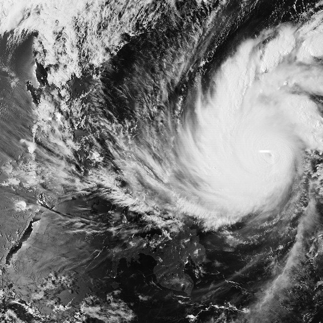
Typhoon Hagupit, seen here by moonlight on the early morning of the 5th, is approaching the Philippines. It’s about 550 km (350…

Typhoon Hagupit, seen here by moonlight on the early morning of the 5th, is approaching the Philippines. It’s about 550 km (350 mi) across, nearing the central Philippines to the west, where it’s forecast to make landfall on Saturday. Many of the areas in its path are still recovering from the record-breaking Supertyphoon Haiyan, more than a year ago.
Experts say that while it’s not as intense as Haiyan, Hagupit (known locally as Typhoon Ruby) is likely to cross the Philippine islands unusually slowly. That will mean powerful winds will last longer and more rain will fall. Some mountainous areas may receive as much as 50 cm (20 inches) of rain over 2–3 days. After the worst is past, supplies may be slow to reach hard-hit areas, because travel will be difficult for longer than usual. The coast guard has already suspended sea traffic, and predicts storm surges of up to 4 m (13 ft) in some areas. Half a million people have evacuated as of late on the 4th, with more expected as it’s made mandatory in some landslide-prone areas.
This image is from the VIIRS sensor on the National Oceanic and Atmospheric Agency (NOAA)’s Suomi-NPP satellite. Its “day-night band” is sensitive enough to work even during the night half of its orbit. The city lights of Manila (population 25 million) are faintly visible on the coastline in the west of this view, where the land appears dark against the moonlit water. Near the eye of the typhoon is a bright stripe, which shows a lightning strike at exactly the instant the sensor swept over that point. (via http://instagram.com/p/wPbR5jTed5/)